By Our Correspondent
NEW DELHI/BHUBANESWAR: According to the National Weather Forecasting Centre of the India Meteorological Department (IMD). Cyclonic Storm ‘Yaas’ (pronounced as ‘Yass’) over Eastcentral Bay of Bengal – (Cyclone Alert for Odisha – West Bengal coasts-Yellow Message).
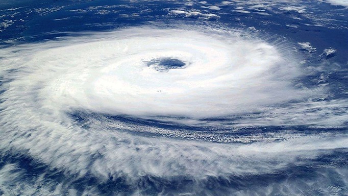
Yesterday’s Depression over eastcentral Bay of Bengal (BoB) moved west-north-westwards and intensified into a deep depression over the same region in the midnight (2330 hrs IST of 23rd May). Thereafter, it moved slowly north-north-westwards and intensified into the cyclonic storm “YAAS” over eastcentral BoB in the early morning (0530 hrs IST) of today, the 24th May, 2021.
It lay centred at 0830 hrs IST of today, the 24th May, 2021 over Eastcentral Bay of Bengal near latitude 16.4°N and longitude 89.6°E, about 620 km north-northwest of Port Blair (Andaman Islands), 530 km south-southeast of Paradip (Odisha), 630 km south-southeast of Balasore (Odisha) and 620 km south-southeast of Digha (West Bengal).
It is very likely to move north-north-westwards, intensify further into a Severe Cyclonic Storm during next 12 hours and into a Very Severe Cyclonic Storm during subsequent 24 hours. It would continue to move north-north-westwards, intensify further and reach Northwest Bay of Bengal near north Odisha and West Bengal coasts by 26th May early morning. It is very likely to cross north Odisha-West Bengal coasts between Paradip and Sagar islands around noon of 26th May as a Very Severe Cyclonic Storm.North Coastal Andhra Pradesh: Light to moderate rainfall at many places with heavy falls at isolated places on 24th May and heavy to very heavy falls at isolated places on 25th May.
Odisha: Light to moderate rainfall at many places with heavy falls at isolated places over Coastal Odisha on 24th, with heavy to very heavy rainfall in Puri, Jagatsinghpur, Khurda, Cuttack, Kendrapara, Jajpur, Bhadrak, Balasore districts and heavy over Ganjam, Dhenkanal, Mayurbhanj districts on 25th, heavy to very heavy rains at a few places with extremely heavy falls at isolated places in Jagatsinghpur, Cuttack, Kendrapara, Jajpur, Bhadrak, Balasore, Mayurbhanj, Dhenkanal, Keonjhargarh and heavy falls at isolated places in Puri, Khurda, Angul, Deogarh, Sundergarh on 26th May and heavy rainfall at isolated places in north interior Odisha on 27th.
West Bengal & Sikkim: Light to moderate rainfall at most places with heavy to very heavy rainfall over Medinipur, South 24 Parganas and heavy rainfall at isolated places in Howrah, Hooghly, & north 24 Parganas districts on 25th, extremely heavy rainfall at isolated places over Jhargram, Medinipur, south 24 Parganas and heavy to very heavy rainfall at a few places Purulia, Bankura, Bardhaman, Howrah, Hooghly, Kolkata , north 24 Parganas, Bhirbhum and heavy falls at isolated places over Nadia, Murshidabad, Darjeeling Districts on 26th May and heavy to very heavy rain at isolated places in Malda & Darjeeling, Dinajpur, Kalimpong, Jalpaiguri, Sikkim and heavy rain at a few places over Bankura, Purulia, Bardhaman, Bhirbhum & Murshidabad on 27th May.
Jharkhand: Light to moderate rainfall at most places with heavy to very heavy rainfall and extremely heavy falls at isolated places on 26th & 27th May and isolated heavy falls on 28th May.
Bihar: Light to moderate rainfall at most places with heavy to very heavy rainfall and extremely heavy falls at isolated places on 27th May and isolated heavy to very heavy falls on 28th May.
Assam & Meghalaya: Light to moderate rainfall at most places with heavy to very heavy rainfall at isolated places on 26th & 27th May.
Gale winds speed reaching 65–75 kmph gusting to 85 kmph prevailing over West central adjoining Eastcentral Bay of Bengal. It is very likely to increase further becoming Gale wind speed reaching 90 – 100 kmph gusting to 110 kmph over major parts of central Bay of Bengal by 24th evening and would decrease gradually from 25th Afternoon.
Squally wind speed reaching 40-50 kmph gusting 60 kmph is very likely to prevail over North Bay of Bengal and adjoining west central Bay of Bengal along and off north Andhra Pradesh-Odisha–West Bengal–Bangladesh coasts from 24th afternoon. It would increase gradually becoming 50-60 kmph gusting to 70 kmph from 25th forenoon. It would further increase becoming gale wind speed 60-70 kmph gusting to 80 kmph from 26th early hours over northwest Bay of Bengal and along and off West Bengal & north Odisha and Bangladesh coasts. It would gradually increase further becoming 90-100 gusting to 110 kmph from 26th morning and increase thereafter becoming 155-165 kmph gusting to 185 kmph at the time of landfall.
Squally wind speed reaching 40-50 kmph gusting 60 kmph is very likely to prevail over south Jharkhand from on 26th noon and increase gradually becoming 110-120 kmph gusting to 130 kmph during 26th evening / night.
Squally wind speed reaching 55-65 kmph gusting to 75 kmph likely over north interior districts of Odisha, interior districts of Gangetic West Bengal during 26th evening to 27th morning.
Squally wind speed reaching 50–60 kmph gusting to 70 kmph prevailing over eastcentral Bay of Bengal and adjoining north Andaman Sea during next 12 hours.
Sea condition is High to Very High over West central & adjoining eastcentral Bay of Bengal. It is very likely to become Very High to Phenomenal over northern parts of central Bay of Bengal, north Bay of Bengal and along & off north Andhra Pradesh-Odisha–West Bengal-Bangladesh coasts during 24th – 26th May.
The fishermen are advised not to venture into central Bay of Bengal during 24th–25th May and into north Bay of Bengal and along & off north Andhra Pradesh-Odisha-West Bengal–Bangladesh coasts from 24th – 26th May.
Those who are out in the Deep Sea of north and adjoining central Bay of Bengal are advised to return to the coast.
(v) Storm surge warning. Tidal waves of height 2-4 meters above astronomical tide are likely to inundate low lying coastal areas of Jhargram, south 24 Parganas, Medinipur, Balasore, Bhadrak, Kendrapara & Jagatsinghpur Districts around the time of landfall.The intensification & likely movement of the system is under continuous surveillance and the concerned state governments are being informed regularly.


