By Our Correspondent
NEW DELHI: According to the National Weather Forecasting Centre/Regional Meteorological Centre, New Delhi of the India Meteorological Department (IMD): A Low Pressure Area is likely to form over north Bay of Bengal & neighbourhood around 19th June.
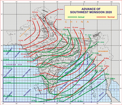
Southwest Monsoon has further advanced into some more parts of West Madhya Pradesh, most parts of East Madhya Pradesh, and some more parts of East Uttar Pradesh.The Northern Limit of Monsoon (NLM) now passes through Kandla, Ahmedabad, Indore, Raisen, Khajuraho, Fatehpur and Bahraich.
A cyclonic circulation lies over East Uttar Pradesh & neighbourhood and extends upto 3.6 km above mean sea level and a trough runs from northwest Rajasthan to the cyclonic circulation over East Uttar Pradesh across south Haryana and West Uttar Pradesh and extends upto 0.9 km above mean sea level. Under the influence of these two systems:
Scattered heavy to very heavy falls and isolated extremely heavy falls over Konkan & Goa during next 2 days and isolated heavy to very heavy falls over Madhya Maharashtra during next 2 days.
Rainfall intensity over East India is likely to increase and isolated heavy to very rainfall is likely over the region during 17th-19th June, 2020 and isolated heavy to very heavy rainfall is likely over Sub-Himalayan West Bengal & Sikkim during next 5 days.
Widespread rainfall with isolated heavy falls likely to continue over Assam & Meghalaya and Tripura & Mizoram during next 5 days with isolated heavy to very heavy falls over west Assam & Meghalaya during next 3 days.


