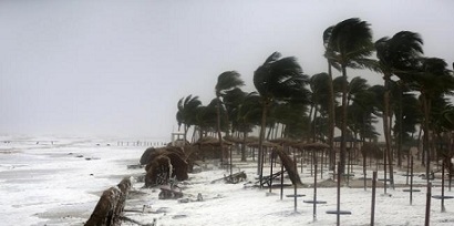
By Our Correspondent
NEW DELHI/BHUBANESWAR: According to the National Weather Forecasting Centre of the India Meteorological Department (IMD): (Time of issue: 1500 hours IST, Dated: 23-05-2021, INDIA METEOROLOGICAL DEPARTMENT)
Depression over eastcentral Bay of Bengal– (Pre-Cyclone watch for Odisha – West Bengal coasts).Latest satellite imageries and Ocean Buoy observations indicate that yesterday’s low pressure area which became well marked over eastcentral Bay of Bengal in the same evening has concentrated into a Depression over eastcentral Bay of Bengal and lay centred at 1130 hrs IST of today, the 23rd May, 2021 near latitude 16.1°N and longitude 90.2°E, about 560 km north-northwest of Port Blair (Andaman Islands), 590 km east-southeast of Paradip (Odisha), 690 km south-southeast of Balasore (Odisha) and 670 km south-southeast of Digha (West Bengal).
It is very likely to move north-north-westwards and intensify into a Cyclonic Storm by 24th May morning and further into a Very Severe Cyclonic Storm during the subsequent 24 hours. It would continue to move north-north-westwards, intensify further and reach Northwest Bay of Bengal near West Bengal and north Odisha coasts by 26th May morning. It is very likely to cross north Odisha – West Bengal between Paradip and Sagar islands by evening of 26th May as a Very Severe Cyclonic Storm.
Andaman & Nicobar Islands: Light to moderate rainfall at most places with heavy to very heavy falls at isolated places on 23rd & 24th May.Odisha:Light to moderate rainfall at many places with heavy to very heavy rainfall at isolated places in the north coastal districts on 25th, heavy to very heavy rains at a few places with extremely heavy falls in Balasore, Bhadrak, Kendrapara, Mayurbhanj and heavy to very heavy falls at a few places in the districts of North Odisha namely Jagatsinghpur, Cuttack, Jajpur and Keonjhar on 26th May.
West Bengal & Sikkim:Light to moderate rainfall at most places heavy to very heavy rainfall over Medinipur, South & north 24 Parganas, Howrah and Hooghly districts on 25th, extremely heavy rainfall at isolated places over Jhargram, Medinipur, North & south 24 Parganas, Howrah, Hooghly, Kolkata and heavy to very heavy rainfall at a few places over Nadia, Bardhaman, Bankura, Purulia, Bhirbhum and heavy falls at isolated places over Murshidabad, Malda and Dakshin Dinajpur Districts on 26th May and extremely heavy rain at isolated places in Malda & Darjeeling, heavy to very heavy rains in Dinajpur, Kalimpong, Jalpaiguri, Sikkim and heavy rain at a few places over Bankura, Purulia, Bardhaman, Bhirbhum & Murshidabad on 27th May.
Squally wind speed reaching 45–55 kmph gusting to 65 kmph is likely to prevail over and around Andaman & Nicobar Islands, Andaman Sea & adjoining eastcentral and southeast Bay of Bengal on 23rd May. It is very likely to increase becoming 55–65 kmph gusting to 75 kmph over eastcentral Bay of Bengal and adjoining north Andaman Sea from 23rd Night. It is very likely to increase further becoming Gale wind speed reaching 65 to 75 gusting to 85 over major parts of central Bay of Bengal from 24th forenoon for subsequent 12 hours and would decrease gradually thereafter.
Squally wind speed reaching 40-50 kmph gusting 60 kmph is very likely to prevail over North Bay of Bengal and along and off Odisha – West Bengal – Bangladesh coasts from 24th evening. It would increase gradually becoming 50-60 kmph gusting to 70 kmph from 25th evening. It would further increase becoming gale wind speed 60-70 kmph gusting to 80 kmph from 26th early hours along and off West Bengal & adjoining north Odisha and Bangladesh coasts. It would gradually increase further becoming 90-100 gusting to 110 kmph from 26th forenoon and increase thereafter till 26th evening.
Sea conditions will be rough to very rough over Andaman Sea & adjoining eastcentral Bay of Bengal on 23rd & 24th May, High to very High / Phenomenal over major parts of central Bay of Bengal, north Bay of Bengal and along & off Odisha – West Bengal – Bangladesh coasts during 24th – 26th May.
Tidal waves of 1- 2-meter height very likely to inundate low lying areas of Andaman & Nicobar Islands on 23rd & 24th May.The fishermen are advised not to venture into southeast & east central Bay of Bengal, Andaman Sea and along and off Andaman & Nicobar Islands during 23rd – 24th May, into central Bay of Bengal from 23rd – 25th May and into north Bay of Bengal and along & off West Bengal – Odisha – Bangladesh coasts from 24th – 26th May.
Those who are out in the Deep Sea of eastcentral & adjoining northeast Bay of Bengal are advised to return to the coast.The intensification &likely movement of the system is under continuous surveillance and the concerned state governments are being informed regularly.


