By Pallava Bagla
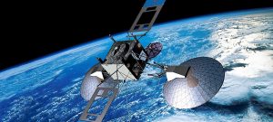
NEW DELHI:The Indian space agency made a very special dash to complete India’s NAVIC – “Navigation with Indian Constellation” when the last of the seven satellites was successfully placed in the orbit by the polar satellite launch vehicle on April 28, 2016. The Indian satellite constellation is already providing 24/7, 365 day coverage of the navigation signal throughout the Indian region. This is a unique achievement by Indian Space Research Organization (ISRO).
In the world today, over South-Asia, there are only 2 other agencies which provide satellite based navigational signals, the first being the signal which is beamed down through the American constellation of the Global Positioning System (GPS) and the other is the Russian constellation which provides the signal through a system called GLONASS. ISRO claims that the accuracy of the Indian navigation system is superior to both these systems for the South-Asian region.
ISRO is known for its frugal technology, hence the NAVIC has been made operational with just 7 satellites. In comparison the American and Russian systems use 4 times as many satellites, the difference being that the Indian NAVIC provides a signal which is regional in nature as compared to the global footprint of American and Russian systems.
The Indian space agency has designed a system in such a manner that the assured signal is available not just over India but in an envelope which extends 1500 kms around India’s borders. This, experts say, has been arrived at based on the threat perception as viewed by India in the current circumstances.
NAVIC provides 2 types of signals, first being a signal which is available for the average user and can be tapped on any compatible smart phone. ISRO says that the accuracy of the signal on this frequency would be better than 20 meters. In addition, ISRO provides a special more accurate signal for “restricted users”, which is a signal that will largely be used by India’s security establishments to make sure that India’s borders are well protected.
The ISRO has spent close to Rs.1400 crore in making this satellite based navigation system a reality.
In 2013, when India launched the first of the seven satellites necessary for the NAVIC constellation, at that time it was thought that India was the 6th country to attempt having their own satellite based navigation system with USA, Russia, European Union, Japan and China all actively pushing the frontier on satellite based navigation systems.
But in 2016, when under the leadership of Prime Minister Shri Narendra Modi, the ISRO completed the deployment of the NAVIC system, India has become the 3rd country to have such a system over South Asia. ISRO was the late starter but made a dash, caught up and completed the system in a record 3 years. Both Americans and Russians took more than a decade to complete their satellite based navigation systems.
India’s Science and Technology Minister, Dr. Harsh Vardhan, during his speech at the National Technology Day function (11th May 2016), said India embarked on having a navigation system using satellites when during the Kargil conflict access to such signal was denied to India. He said that it showed the tremendous capability the Indian science and technology establishment had in giving a totally Made-in-India effort for its population.
On the successful launch of the seventh and last satellite in the Indian Regional Navigation Satellite System (IRNSS), the launch was monitored live by the space buff in Prime Minister Shri Narendra Modi who immediately after the launch gave an extempore speech giving ways in which the system could be utilized.
The Prime Minister also named it NAVIC- to honour the legendary Indian sailor. He said that these brave men in times past used to navigate the sea using stars but now there is a new star from ISRO which will help in easy navigation. Interestingly, in continuation of PM’s policy of befriending India’s immediate neighbours, he said India is willing to extend the services of NAVIC to its South Asian neighbours. The Prime Minister said, “With this successful launch, we will determine our own paths powered by our technology. This is a great gift to people from scientists”. He described this as an example of “Make in India” and “Made for Indians.”
The signal from NAVIC is already being received on a select few compatible smart phones. In times to come, the expectation is that all Indian handsets will be made compatible using chipsets that are enabled to receive signals from NAVIC. The idea being that Indian entrepreneurs will be able to use Indian signals as they deploy more and more uses of such a system in the Digital India of future.
India may no longer need to depend on foreign vendors for providing satellite based navigation systems. This would make India more resilient in the future.
For an average user, the NAVIC signal would be an easy way for finding road routes as they travel in India and help in more effective deployment of the transportation sector. It is also expected that the signals will be used to monitor the movement of trains in the vast Indian railway network. This would make road, rail and ship transport better streamlined, cheaper and cost-efficient. It is also hoped that the signal from NAVIC would help Indian women feel safer as more and more mobile phones are made compatible and women would be in a position to send distress or panic signal using the panic button which is to be introduced on Indian phones by 2018.
ISRO has once again shown how frugal but effective engineering can help not only secure Indian borders but also give a fillip to the Indian economy.
(The writer Pallava Bagla is Science Editor for a TV Channel. The views expressed are personal, Curtsey PIB) .


